USGS
Bench Mark
"DW 4698"ca. 1898
Jerry Penry
May 30, 2010
Bench Mark 4698 was established in the Black Hills sometime around the year 1898. It was referenced to the Deadwood Datum which depended upon a bench mark at Deadwood, South Dakota. Bench marks on the early USGS datums usually had the datum code and the elevation to the nearest foot stamped on them, so this bench mark was known as "DW 4698". When the Deadwood Datum was tied to the precise USC&GS datum a few years later, the elevation changed, but the bench mark kept the original name.This bench mark was established in a canyon west of a small town known as Silver City where Rapid Creek flows. When the early USGS surveyors came through the canyon with the leveling, there was a trail road. In 1906 the Rapid City, Black Hills & Western Railroad built their tracks through the same narrow canyon. The railroad was short-lived, having been removed from the canyon in the year 1948. Today the narrow canyon is a scenic hiking trail known as the Deerfield Trail.
The last time this monument was referenced occurred in 1934 when surveyors from the U. S. Coast & Geodetic Survey used it during the course of their work which was most likely a Works Progress Administration survey. They noted the monument as being on a small rock shelf at the foot of a cliff. It was noted as being 7.6 feet north of the north rail of the railroad. A reference to it being at the entrance of Jenney Gulch to Rapid Creek is incorrect as it is actually at the entrance of Kelly Gulch. In 1952 surveyors with USGS ran a transit traverse through this canyon and established a nearby monument on the same rock wall, but no mention was made about bench mark DW 4698. The old railroad town of Canyon City used to be located just west of this area.
Despite the remote location, and the fact that the rock wall and ledge can still be easily found, the bench mark was not located. The finding of one of the original witness trees confirmed that I was searching in the correct location.

The area where bench mark "DW 4698" was placed.

The original description.

The scenic canyon trail just west of Silver City.

The canyon has high walls as shown by this scene.

Many places along the trail are very narrow between the rock wall and Rapid Creek.

The Deerfield Trail sign.
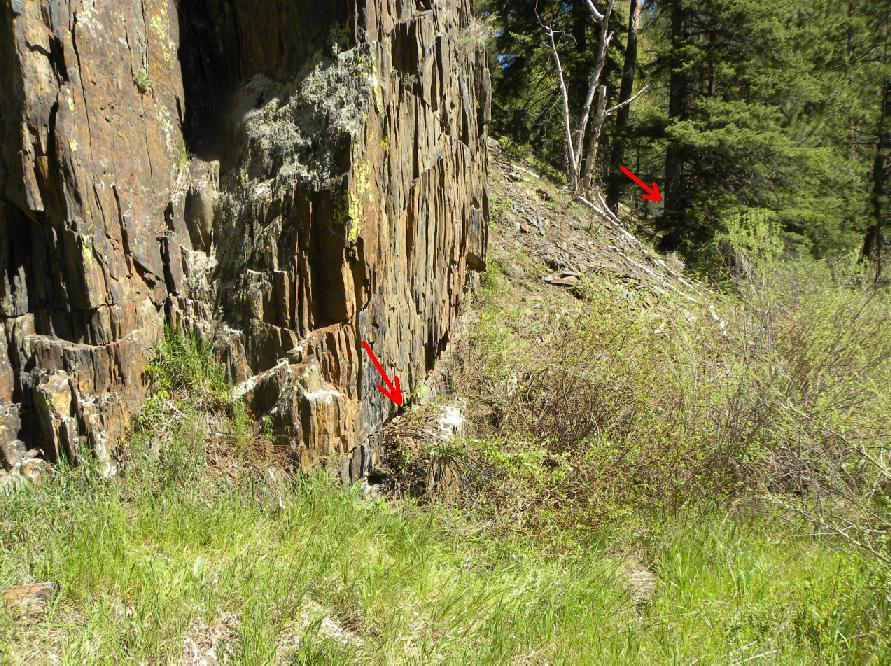
The old USGS bench mark "DW 4698" should have been located on this ledge according to the description.
The red arrow pointing to the tree in the background is one of the original blazed witness trees.

A metal detector (non-ferrous) was used on the ledge and all around the base, but no trace of the old brass disk could be found. Yes, that is DEFINITELY poison ivy!

One of the original witness trees. This tree matched the 65' distance exactly to the rock ledge. The tree is now 20" in diameter.


The blazed area where the markings were made on the tree.

Backside of the tree and the location where the bench mark should have been located (red arrow).

The same rock wall where a newer USGS monument was found just a little ways to the west.

This transit traverse monument was placed in 1952 by USGS surveyor R. H. Arneson.

Nice view of the bench mark with moss on the rock ledge.

Close-up of the 1952 USGS monument.

A train winds through the canyon where "DW 4698" was located.
The USGS surveyors entered the canyon approximately 8 years before the railroad came.
Then when USGS came through again, their transit traverse of 1952 tied in the location of the abandoned railroad.
(South Dakota State Historical Society photo).
Other Deadwood Datum Bench Marks
© Jerry Penry 2010

