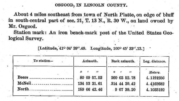
USGS
Triangulation Station
"NORTH PLATTE BASE LINE"1892
Jerry Penry
October 4, 2007
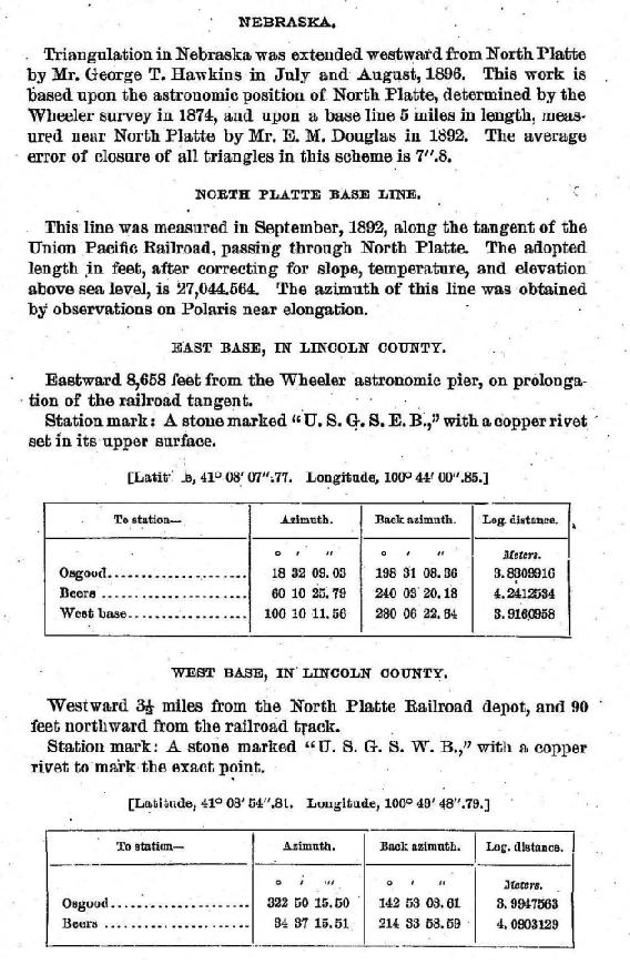
The following paragraph appeared in the 14th Annual Report of the U. S. Geological Survey (1892-93)."Base Line – During the month of September Mr. Douglas measured a base line along the railroad west of North Platte, Nebraska. This line was measured with a 300-foot steel tape, which was tested by comparison with the standard of the U.S. Coast and Geodetic Survey both before and after use. The measurement was made at night, with a resulting length of base, after all corrections were made, of 8,243.593 meters. The measured line was transferred by offsets to permanent stone posts set firmly in the ground 90 feet from the track, the station points being marked on copper bolts set in the stones, and the line between these stations, after azimuth determinations were made, used as a base for work in Nebraska."
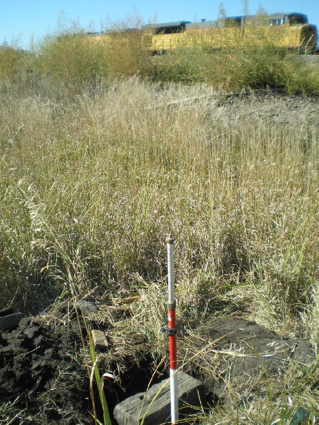
The base line end points established by USGS in 1892 at North Platte are two of the oldest geodetic monuments placed in Nebraska with the exception of the work done a few years earlier along the Missouri River by the Missouri River Commission. They appear to be the first permanent monuments established in Nebraska by USGS. The base line was needed to triangulate the North Platte River westward to the area of Broadwater, Nebraska, in eastern Morrill County for future topographic mapping. Although the base line was established in 1892, the triangulation did not take place until four years later in 1896. Besides the base line end points, there were also 19 other points established in the triangulation network which consisted of brass caps on iron pipes.
The 18th Annual Report of the U. S. Geological Survey (1896-97) published the
latitude and longitude positions for the points in the triangulation network.
Two stations in the USGS network, "North" and "Osgood", have been occupied by the U.S. Coast & Geodetic Survey and therefore have geodetic positions referenced to NAD(83)1995. This gave a direct comparison to the 1896 positions to that of today on the same monuments.
The historical latitude by USGS in 1896 was found to be an average of 2.88 seconds greater than the NAD(83)1995 value, while the historical longitude by USGS in 1896 was found to be an average of 6.73 seconds greater than the NAD(83)1995 value. This average difference in latitude/longitude was applied to the historic position for the monument at East Base to derive an approximate NAD(83)1995 value.
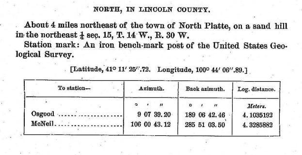
By using an adjusted position to match NAD(83)1995 for East Base, a handheld GPS reciver was used by Gene Thomsen on October 4, 2007, in an attempt to find the monument. Within a short time the monument was found after probing the earth in the area calculated and staked out with the handheld GPS.
The stone monument for EAST BASE. (Gene Thomsen photo).
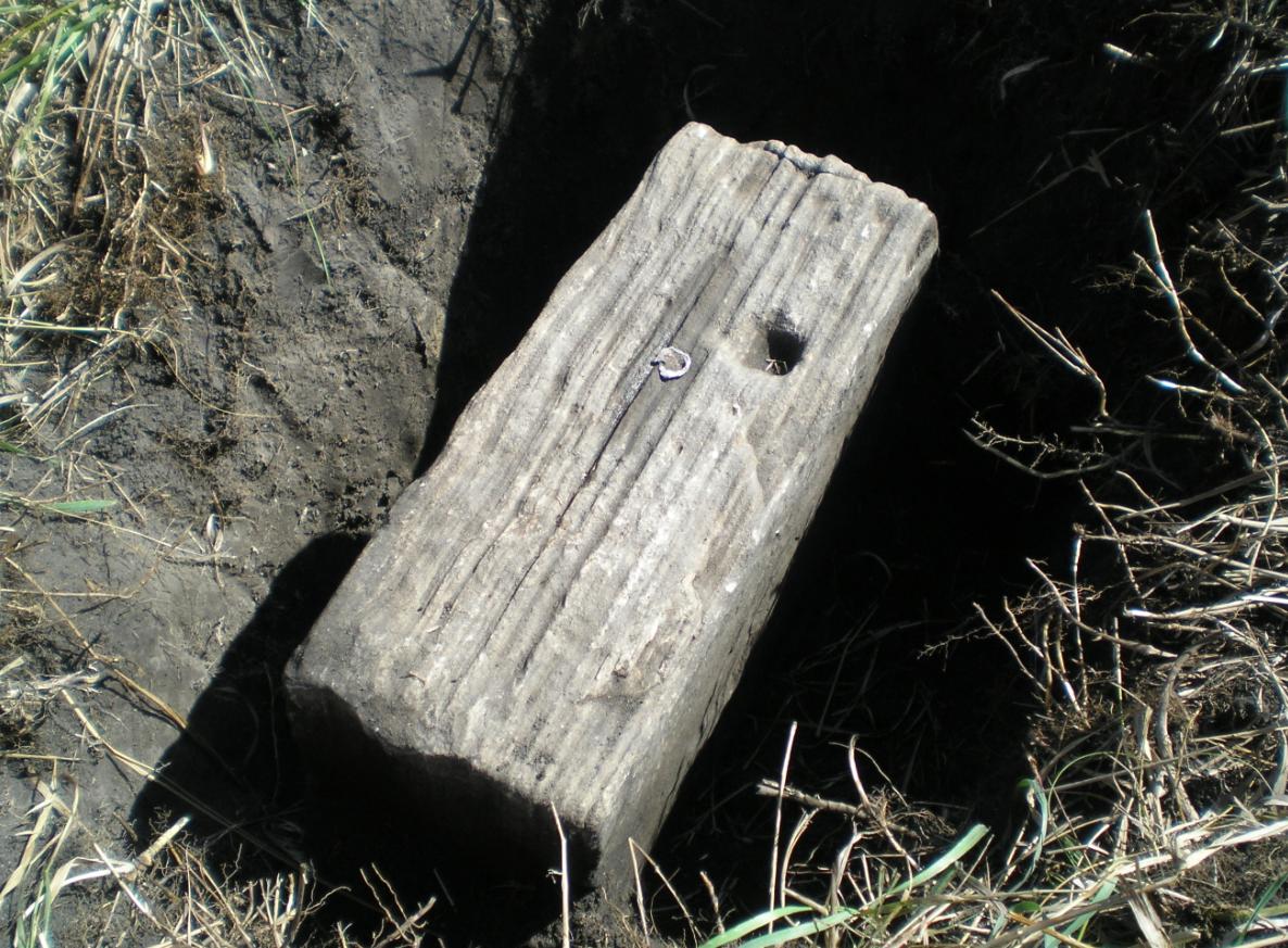
The copper bolt leaded into the stone for the exact point. (Gene Thomsen photo).
The monument with the Union Pacific Railroad in the background. (Gene Thomsen photo).
Aerial view of the North Platte Base Line along the Union Pacific Railroad.